The convergence of Storm Dave with the Easter bank holiday creates a localized economic and logistical bottleneck. While general media coverage focuses on the inconvenience of "bad weather," a structural analysis reveals that the primary risk lies in the specific synchronization of peak travel demand with a high-gradient pressure system. The arrival of a deep Atlantic depression during a period of maximum infrastructure utilization forces a trade-off between kinetic throughput (travel speed) and operational safety.
The Tri-Factor Mechanical Strain
The disruption caused by Storm Dave is not a singular event but a product of three intersecting variables. When these variables align, the margin for error in national infrastructure approaches zero.
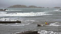
- Pressure Gradient Intensity: The rapid drop in millibars—cyclogenesis—dictates the peak gust velocity. For Storm Dave, the tightening of isobars across the UK and Ireland creates a venturi effect in coastal and mountainous corridors.
- Thermal Contrast and Precipitation State: The transition of rain to snow is governed by the $0^\circ\text{C}$ isotherm. During Easter, the air mass is often marginal; a $1^\circ\text{C}$ shift determines whether the result is liquid runoff or a significant accumulation of snow that increases the "drag" on road and rail networks.
- Cyclical Demand Peaks: Easter weekend represents one of the highest periods of domestic migration. Unlike mid-winter storms where the public can more easily retreat, holiday travel is driven by non-negotiable social and commercial deadlines, leading to higher risk-taking behavior among travelers.
Kinetic Energy and Transport Vulnerability
The primary danger to high-sided vehicles and rail infrastructure is the transfer of kinetic energy from the wind to stationary or moving objects. Wind pressure increases at a squared rate relative to its velocity. The formula for wind pressure is $P = 0.613 \times v^2$, where $v$ is the wind speed in meters per second. This means that a 70mph gust exerts nearly double the force of a 50mph gust.
The Deceleration of Rail Networks
Rail operations face a binary choice when gusts exceed specific thresholds. Above 60mph, many networks implement blanket speed restrictions. These are not merely cautionary; they are required to account for the increased stopping distance of trains under high-wind conditions and the probability of debris—such as fallen trees or overhead line damage—appearing within the driver's line of sight. When speed is halved, the capacity of the track is reduced by significantly more than 50% due to the compounding effect of bottlenecking at major junctions.
Maritime and Aviation Stalling
For air travel, the limitation is rarely the wind speed itself but the crosswind component and the resulting turbulence on final approach. Aircraft have specific "crosswind limits" defined by the manufacturer. Storm Dave’s predicted track suggests a prevailing south-westerly shift, which puts many major UK runways—which are often oriented east-west—at a disadvantage. Expect "go-around" maneuvers to increase, which further consumes fuel and reduces the landing rate per hour.
The Physics of Easter Snowfall
Snowfall during the spring months is often "wet snow," characterized by a high water-to-ice ratio. This material is significantly heavier than the "powder" seen in colder, continental climates.
- Structural Loading: Heavy, wet snow adheres to power lines and tree branches. When combined with high wind speeds (galloping), this leads to mechanical failure of the electrical grid.
- Thermal Inertia: The ground temperature in late March and early April is typically higher than in January. This creates a layer of meltwater beneath any accumulating snow, resulting in a low-friction interface that makes road surfaces more dangerous than during deeper freezes.
- Visibility Thresholds: Snowflakes in a high-wind environment (blizzard conditions) create a whiteout effect by scattering light in all directions. This reduces the effective range of human vision to less than 10 meters, rendering high-speed travel physically impossible regardless of vehicle capability.
Quantifying the Economic Friction
The economic impact of Storm Dave is a function of "forced idleness" and "logistical latency."
The retail sector, which relies on a surge in Easter spending, faces a sudden drop in footfall. However, the more significant cost is found in the supply chain. Just-in-time delivery systems are built on the assumption of predictable travel times. When a storm forces a 24-hour delay across the freight network, the resulting backlog takes roughly 72 to 96 hours to clear. This is the "recovery lag."
The cost function of the storm includes:
- Direct Infrastructure Damage: Repairs to the National Grid and rail signaling.
- Insurance Liability: Claims arising from property damage caused by high-velocity debris.
- Opportunity Cost: The value of lost labor hours and canceled commercial events.
Predictive Behavioral Response
Human behavior under storm warnings follows a predictable decay curve. Initial warnings (48-72 hours out) result in high levels of preparation and some travel cancellations. As the event nears (12-24 hours), a "sunk cost" fallacy often takes over, where individuals who have already paid for travel or accommodations attempt to proceed despite deteriorating conditions. This leads to the highest concentration of emergency service call-outs in the hours immediately preceding the peak of the storm.
The presence of "Dave" as a named storm serves as a psychological anchor. Naming a depression increases the public's perception of risk by 20-30% compared to unnamed weather events of similar intensity. This naming convention is a strategic tool used by meteorological agencies to force a reduction in the "total active population" on the roads.
Strategic Operational Directives
To mitigate the impact of Storm Dave, stakeholders must move from reactive "emergency mode" to a proactive "load shedding" strategy.
- Transport Operators: Prioritize the movement of high-capacity rail over individual vehicle traffic. Shutting down vulnerable coastal lines early allows for the reallocation of staff to inland hubs where they can manage the inevitable congestion.
- Public Safety Agencies: Shift the messaging from "be careful" to "operational cessation." Clear directives that define the exact hour when travel should stop prevent the mid-journey stranding of thousands of commuters.
- Individuals: Recognize that the $0^\circ\text{C}$ threshold is the most volatile variable in the system. A fluctuation of a fraction of a degree will change a clear road into an impassable ice sheet within sixty minutes.
The most effective strategy during Storm Dave is the "Front-Loading of Logistics." Ensure all essential transit is completed 12 hours before the predicted pressure minimum crosses the meridian. Once the pressure gradient peaks, the only viable operational stance is total stasis until the thermal profile stabilizes and the wind velocity drops below the structural failure threshold of local vegetation and power infrastructure.